Sun streams under the evening clouds, lighting us up on Raven Ridge. We are glowing, and not from exertion. Eighteen Vermont Master Naturalists just spent five hours hiking a quarter of a mile with me. We smelled the sharp wintergreen scent of black birch sap, rubbed the sulfur yellow buds of a bitternut hickory and gazed at its canker-strewn branches, and we ate bright red American basswood buds (picture a mouse in a motorcycle helmet!) and felt the slippery mucilaginous goo in our mouths. It is Superbowl Sunday or, if you prefer, just another Sunday in the woods chilling with winter trees.
Creating the Vermont Master Naturalist Program is a dream come true. VMN is fertile ground for teaching the layer cake approach and, best of all, it allows me to work with UVM Field Naturalist and Ecological Planning graduates. FNEP alumni Sean Beckett, Sophie Mazowita, and Monica Przyperhart head VMN Chapters in Montpelier, Cambridge, and Middlebury areas. Alumni also lead field days on natural communities, pollinators, and winter tracking and star in VMN films about wildlife habitat and vernal pools.
Nationally, most Master Naturalist programs focus on plants and animals – the charismatic living pieces of the landscape. VMN diverges by building a framework from the ground up, giving natural communities a solid geologic foundation. Besides its holistic approach, VMN is unique in scale. Other master naturalist programs are regional, state-wide or, in one case, national. The Vermont Master Naturalist program is by nature local.
It’s as if the question of VMN’s scale was decided by men sitting around an oak table in Massachusetts 250 years ago, gridding off six-mile-by-six-mile squares on a Vermont map. Those squares became Vermont towns. The founders’ experiences with towns in southern New England taught them that six miles by six miles was a magic number. That distance allowed farmers (and eight out of ten Vermont settlers would be farmers) to travel from anywhere in the town by horse or by foot to the center village, conduct their business, and get home again in time to milk the cows. Center villages by charter had a church (or two or three), a green for military drills, a post office, a store, and often later additions like a pound for loose pigs. Vermonters of European descent embraced their towns and have hung on tightly ever since.
It turns out that telling the story of Vermont in a six-mile-by-six-mile-square area is a piece of cake. All you need are bedrock outcrops, gravel and/or clay pits, stone walls, cellar holes, barns, natural communities, and wildlife to track in winter. Almost all Vermont towns have these features – if you know where to look. And it is fun to look. It’s a game of “let’s find your special places,” whether it’s a glacial spillway over a mountain pass or a hidden glade of lady’s slippers right in the middle of town.
In addition, decisions about school budgets, local taxes, and conservation issues such as managing a town forest, delineating wildlife corridors, or restoring riparian buffers are decided at a town level in Vermont. These decisions are often made by volunteers. It’s a lot to ask of them. Working with Vermont Fish and Wildlife’s Community Wildlife Program, in collaboration with FNEP alumni Jon Kart, Jens Hawkins-Hilke, and Dave Moroney, VMN helps provide ecological training and technical support to these individuals.
Two hundred and fifty years later, the town scale is still a human scale. Vermont Master Naturalists are neighbors who receive ecological training and then work on projects in their town. They know the school where they are planting native plants for pollinators and other wildlife, they know the floodplain where they are removing knotweed and planting trees, they know the places to set cameras to capture wildlife photos, and best of all they get to know each other. As VMN begins to weave a network of alumni through Conservation Field Days and other offerings to address conservation issues at a watershed level, the distance people travel between towns is still manageable. The carbon footprint remains light. And people are amazed by what is right outside their door.
By Kate Taylor, VMN Winooski Headwaters participant 2024. Kate reflects on a 2023 weekend Biodiversity University course offered through North Branch Nature Center.
I took an excellent course on “Reading the Landscape” this past weekend through the North Branch Nature Center, Biodiversity University. Led by Alicia Daniel, it was designed to teach us to tune into the different layers of the land, rather than to simply skim the surface. As anyone who reads my blog knows, I’m a fan of the surface.
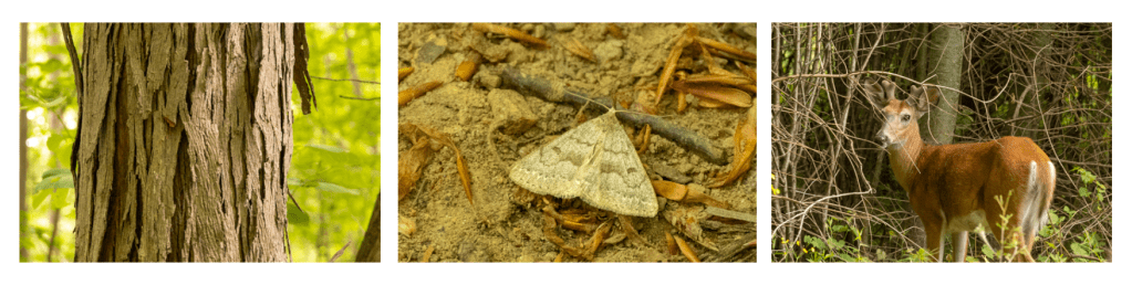
I love to admire the life in front of me, whether that is a beautiful Shagbark Hickory, a Morbid Owlet Moth or a White Tail Deer (all seen this weekend while we were out and about).
But I’m not used to looking much beyond that. This weekend we began with deep history, starting with the collision of the continents and the creation of the bedrock beneath our feet. I confess, I haven’t spent a great deal of time considering bedrock. But, the shape (ridges, valleys, plains…) and the makeup (clay, shale, sandstone…) of the earth beneath our feet formed hundreds of millions of years ago as the continents collided. That shaped the landscape, influencing everything from the formation of lakes and rivers to the minerals found in the soil.
We visited a thrust fault by Lake Champlain where the history of the rocks can be clearly seen by those who know how to look. We considered how the receding waters of Lake Vermont and later the Champlain Sea influenced present day Vermont. From there we looked at the soil composition and how that helps determine the plants and animals than live here.
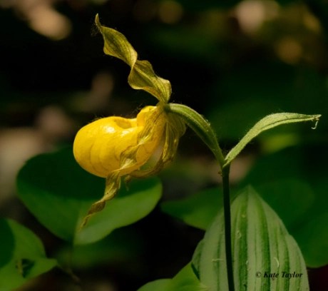
I had never before considered how millions of years of history conspire to create a home for Yellow Lady’s Slippers.
But the weekend wasn’t all deep history.
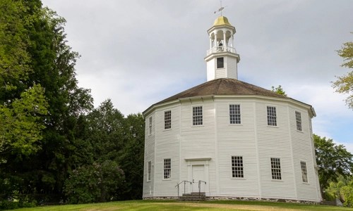
We also visited the Round Church in Richmond with geographer, Jane Dorney, to look at the cultural history of the land, beginning with the colonial times.
The original inhabitants of this land walked more gently and so leave less evidence of their past. The colonial settlers, on the other hand, cleared land for homesteading, eventually clear cutting much of the forested landscape.
That cutting is one way to view their history, as technology changed, allowing for the move from subsistence farming to farming for profit.
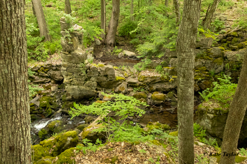
Ruins of an old water-powered mill that was once the height of new technology.
Jane also showed us a beautiful old barn that had been expanded over the centuries, giving a history of farming in it’s beams and floorboards. We talked about how dairy farming is changing still, moving from family farms to large corporate farms. That is also changing our landscape and has an effect on the land and those that live upon it.
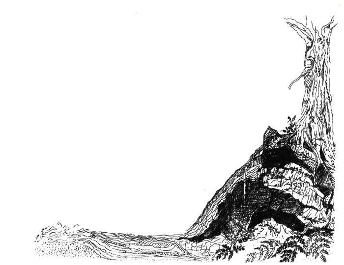
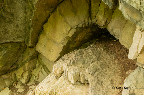
We ended the day with a visit to Raven Ridge where we could put it all together, starting at the boardwalk over a lowland marsh, heading through white cedar to an abandoned beaver pond. Then, up a to a fantastic rock formation, just below a final view overlooking Lake Champlain.
Sometimes, when I stare up at the stars filling the night sky, I feel like a tiny speck in the emptiness of space. This weekend made me realize I also live in a tiny spot of “now” in the vastness of time.
Thanks for looking, Stay well, be curious, learn things.
This is the second part of an article exploring the incredible diversity of Burlington’s landscape across space and time; in particular, we will carry the connections from part one—from oceans, to continental upheaval, to glaciers—forward into the living landscapes of today. For example, how do the seemingly bottomless deltaic sands at Starr Farm continue to influence plant communities so long after the Winooski has changed its course? How does the calcium rich bedrock, formed by the accumulation of shells on ancient ocean floors, write itself in the carpet of ephemerals throughout our spring forests at Rock Point and Arms Forest? Put otherwise: how do these relics of a distant world constrain and shape what we see today?
Translation by plants
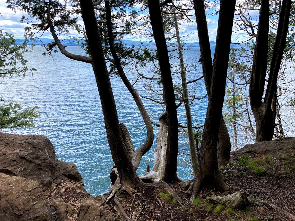
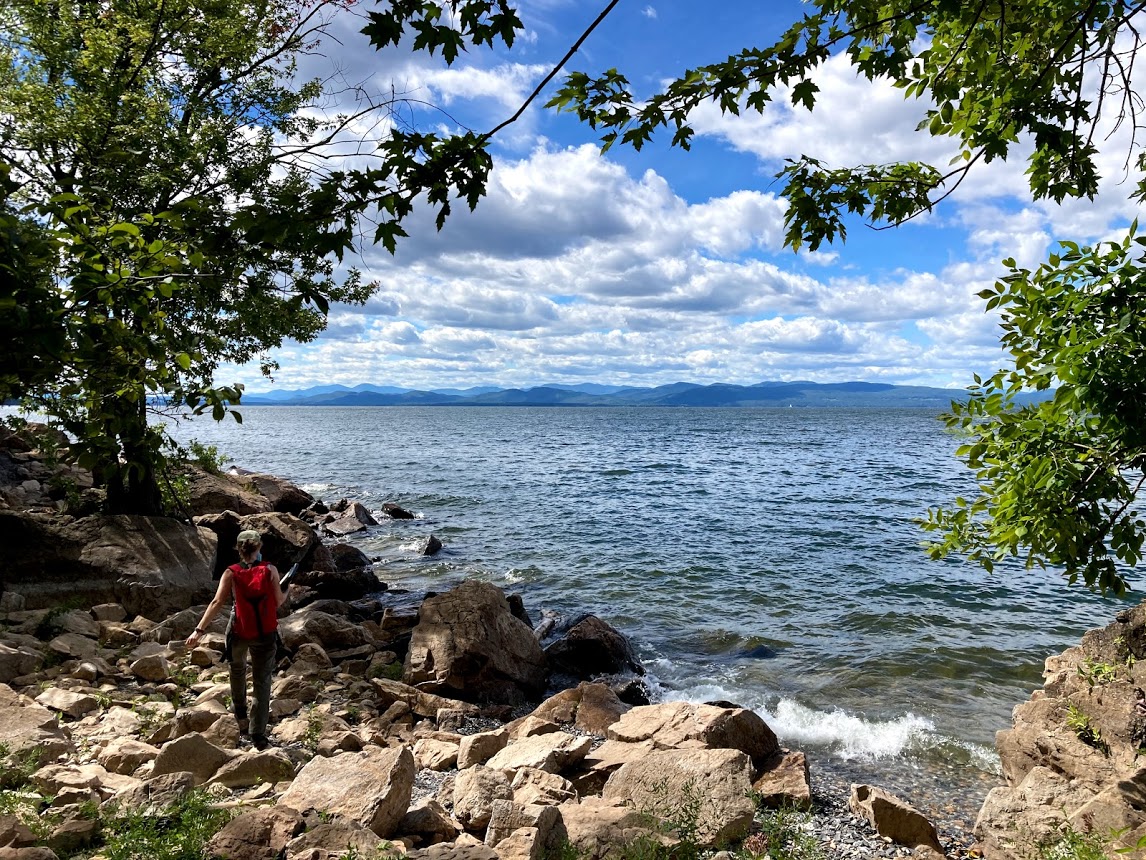
Plants, by presence or absence alone, can unveil features of a landscape otherwise hidden. And when they band together in communities, these hidden features become even easier to pick out. In Burlington, the dolostone bedrock topping the Champlain Thrust fault has written itself into the limestone outcrop communities found from Kingsland Bay, and Red Rocks to Lone Rock Point, Niquette Bay and beyond. These communities occupy the narrow bands of ledges along the lake–or not far from it—and are best recognized by the gnarled, bonsai-like aspect of white cedar. This tree is masterful at anchoring itself to exposed rock—and thrives on the rich deposits of marine calcium that are slowly released from the dolostone. In fact, a panoply of calcium-loving shrubs have also found their way here among the cedars: New Jersey tea, leatherwood, orchids, and several native honeysuckles, as well as the unique species of sedge and fern that spring right from the rock face. Just beyond these ledges, where the soils are deeper and shelter from the lake is greater, hardwood communities form a totally different world, where sugar maple, basswood, and white ash tower overhead.
Photo: Sarah Lindsay
Moving inland from the lake, one arrives in the vast floodplain forests that define Burlington’s lowland landscape; these are best found in places like the Intervale, Derway Island, and Macrae Farm. Massive cottonwoods and silver maples arch across prehistoric mazes of ostrich and cinnamon ferns. Here, the nutrient rich clays and silts deposited yearly by storms and the spring thaw connect these communities less to the bedrock than to the Winooski River, itself more ancient than the glaciers, the lake, and possibly the Green Mountains, which it deftly crosses through.
The Burlington uplands, however, are marked by deep sands, too porous to hold much water or nutrients. Remember, these sands are remnants of the ancient delta where the Winooski once emptied to the Champlain Sea. Sunny Hollow and Starr Farm Park are great examples of what might once have been the dominant community before the city was built: pines and oaks in the canopy, with hardy shrubs, like blueberry, in the understory. In fact, these woods are dry enough to be shaped by fire: burn scars are found here and there at the base of trees, while fire adapted species–notably the pitch pine–thrive here, as nowhere else in the region.
But perhaps the most unique community of plants in the Burlington region is found in the rare but persistent sand dunes along the lake shore. Their shifting slopes are dotted with species of grass and legumes common along the Atlantic coast; and indeed, these communities are vestiges of the time of the Champlain Sea nearly 9,000 years ago, when the whole Champlain basin was merely an estuary of the Atlantic Ocean.
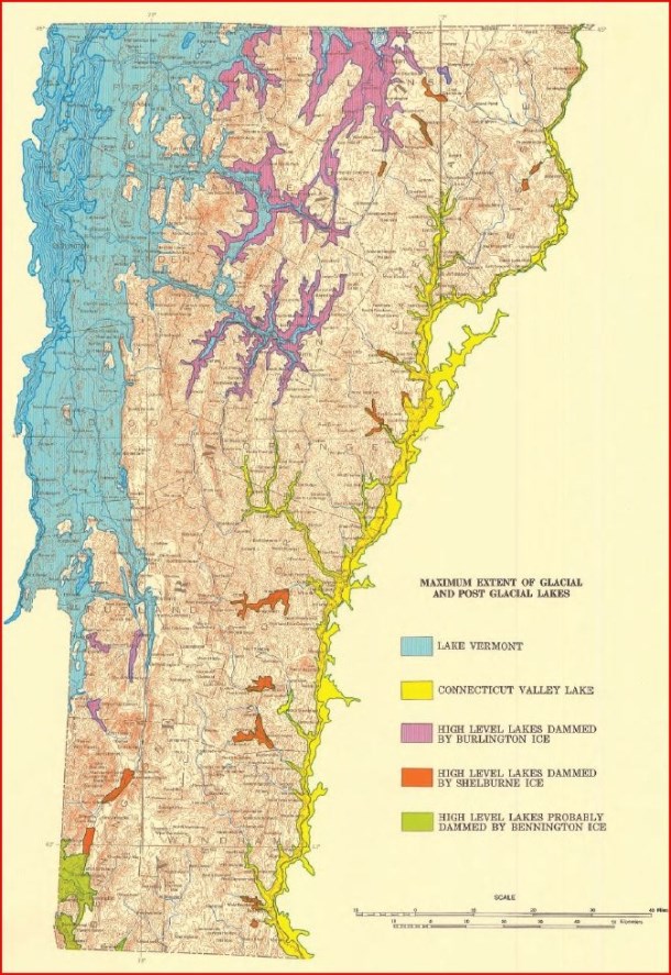
Ancient lakes formed as the ice sheet receded from Vermont. Image from the Surficial Geology Map of Vermont, courtesy of the Vermont Geological Survey.
Translation by wildlife
Unlike its plants, Burlington’s wildlife cannot be so directly linked to bedrock and ancient oceans; the basic drives for food, shelter, and mating renders the Burlington landscape in a remarkably different light. Nonetheless, wildlife can be acute readers of landscapes, and by their signs alone, one can see how the niches and habitats here are nonetheless connected to events of the distant past.
Over millennia, for example, Burlington’s deltaic sands and floodplain silts have proved especially vulnerable to erosion, and today they’re deeply incised by small waterways, like Centennial and Potash Brooks. These wind their way to the Winooski River or to Lake Champlain, creating extensive networks throughout the city, connecting the uplands and points east to these large bodies of water. In many such areas, construction and cultivation has been naturally delimited. This in turn has opened the door to many specialists, like river otters, muskrats, mink, and beavers, signs of which are abundant along the shores and banks throughout Burlington. But this landscape also provides habitat, cover, and browse for other less specialized species, like deer, raccoon, and red foxes, who are deft at exploiting the fruits of a fractured urban environment.
Development and cultivation have likewise been delimited by the dolostone ledges and outcrops described above. Today these areas, chiefly along the Champlain Thrust Fault, constitute some of the most expansive forests in Burlington. This fact is not lost on what are normally deep-woods species, like the Barred Owl and Hermit Thrush, who have made these parts of Burlington home.
Humans: a transformation
The presence of humans in Vermont is traceable only to the end of the last ice age, as the glaciers left no earlier evidence in their wake. Before contact with Europeans, some estimates of native populations in Vermont are around 10,000 people, but the intensive management regimes recorded elsewhere—such as fire to control the underbrush or large-scale land clearing for firewood and agriculture—were likely absent from the Burlington area. Instead, the region’s expansive waterways were used for transportation to and from the otherwise inaccessible mountain wilderness, rich with fish and game. In fact, spearheads found in the Burlington area have been dated to the time of the Champlain Sea and were crafted for the hunting of marine animals, such as small whales; intriguingly, the stone that they were crafted from is traceable to the coasts of Maine and New Brunswick. So early Native Americans in Burlington probably traded with other settlements just north, who traded with other settlements north of them, in series along the northeast waterways. There’s also ample evidence, including archeological finds and oral histories, that the Abenaki people later conducted smaller-scale agriculture in the area’s many floodplains, where there’s easy access to water and where flood deposits make for the fertile soils.
But waves of European settlement across Vermont brought enormous changes to the land. The early French explorers to the north traded the fur of species like beavers, fishers, and possibly even wolverines, reducing their numbers. When conflicts over land shifted the balance toward the English, the fur trade was supplanted by farming, marking another dramatic shift in relations to the land. Land began to be cleared for farming and habitation. Small subsistence farms shifted to larger commercial farms by the early to mid-19th century as Vermont became the epicenter of a global demand for Merino wool. Many more acres of forest were cleared, and wolves and catamounts were seen as threats to farm animals. Trapping and hunting were encouraged with bounties, which extirpated these and many other fur-bearing animals from the region. This opened enormous opportunities for smaller predators, like fox and coyote, while giving large prey species, like deer and moose, free range. What was left of the old forests in Burlington and elsewhere in Vermont all but disappeared, along with many animal species that required them, effectively finishing the work begun by the fur trade.
In this context, the birthplace of Burlington as a city is appropriately Winooski Falls. The first roads in the region were built to connect Rutland to the falls at Vergennes, Shelburne, and Winooski. These waterways powered mills that sawed timber and ground wheat, and allowed for the easy transport of goods in and out of the region. Later, as new markets for Vermont’s resources opened internationally, the first major street in the city, Pearl Street, was built to connect Winooski Falls to the docks along the lakefront. The waterfront grew into a busy commercial area focused on processing and transporting wood and other products to and from Vermont, the eastern US and Canada by water and rail. The iconic estates along Burlington’s southern hillsides were built not long after, some as a consequence of the wealth these new markets generated for a select few. Some wealth, like that of the Hickok’s, whose estate became the Five Sisters neighborhood, was from New York City or another urban areas – those families came to Burlington to buy land and semi-retire. The land associated with these large estates has since been subdivided and developed into the Five Sisters and Hill Section neighborhoods, as well as the Burlington Country Club and UVM’s Redstone Campus.
It can be difficult to parse the shape and influence of the landscape with this onset of intensive use. Nonetheless, some patterns still emerge: today, there are still productive farms on the flat, silty soils of the Intervale, on the clay-rich lake and sea bottom sediments south of town, and along the calcium-rich bands of exposed shale and dolomite. Unlike the rest of the state, stone walls don’t wend most Burlington woods; early farmers in the New North End cultivated nearly bottomless deltaic sands, where rocks were no obstacle. Today, this history is written in white pine, white birch, pin and black cherry, species that readily exploit disturbed soils, while cultivated species like black locust and red pine, still dot the woods here.
The modern era has brought further interventions at every levels of the Burlington landscape, and climate change promises to complicate this portrait with radically different variables. But in face of such monumental changes, the practice of parsing our landscapes retains weight and luster. Out of the richness and diversity found here–out of the full dimensions of time and space–it’s our hope that a larger, place-based perspective can help sustain the hope and resilience necessary to chart a way forward.
To develop intimacy with people it is necessary to understand their history; the same holds true for developing an intimate relationship with place. – Tom Wessels, 2012
Strangely enough, Burlington’s natural history can be told by oceans: their opening, their closing; their patterns of habitation and sedimentation; their in-rush and out-rush; and their transposition on land as glacial ice. While all life on earth is thought to originate from oceans, Burlington’s rich and diverse landscape exposes connections more direct and proximal. Excellent examples of this are the Champlain Thrust Fault at Rock Point and the deep delta sands underlying Starr Farm Park, both of which originated from separate bodies of saltwater. And these links to distant oceans and deep time are more than just curiosities, they’re foundational to translating what we see around us, to appreciating the wilds of Burlington. In this two-part series, we will examine the natural and cultural history of Burlington from the ground up, first by exploring its geology and soils, and later by integrating its plants, animals, and human inhabitants.
A brief overview of Burlington’sgeological history
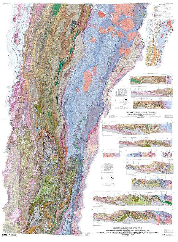
Two immense collisions structure Burlington’s geological past. The first of these collisions occurred roughly 440 to 470 million years ago, a time when the ancient Adirondacks were an equatorial range along the southern coast of what would become North America, then known as Laurentia. The Atlantic had not yet formed, and the rocks undergirding present-day Burlington were still deep under the Iapetus Ocean–an ancient body of water that once stretched between the proto-American and the proto-European continents. Initially, the Iapetus Ocean was shallow and sandy, teeming with coral reefs and shellfish; later it deepened, and its bottom turned to mud. This pattern is recorded in layers of rock: sediments from the shallow, sandy ocean turned to ancient limestones and sandstones, while the sediments from the deep, muddy ocean turned to younger mudstones.
This is important because when the Iapetus Ocean finally began to close, these layers of sandstone, limestone, and mudstone came to define that first immense collisions: driven up from the depths, these layers of rock rode over the edge of the proto-North American continent and were bent, deformed, cracked, dragged, and broken apart; the collision was so powerful that it welded these ocean rocks to the edge of the Adirondacks, right where Lake Champlain now lies; what’s more, it created the thrust fault defining the western edge of Burlington, seen at the ledges of Ethan Allen Park and through Arms Forest, Rock Point, and Oakledge. A second collision followed roughly 100 million years later—355 to 385 million years ago—when an arc of islands smashed into the proto-North American coast. And it was this collision that lofted the Green Mountains from those layers of mudstone, turning them to the schist bedrock that defines the edges of the the Champlain Valley today.
Considerations of bedrock
This story of past upheaval is profoundly connected to the present Burlington landscape by oceanic mudstones, sandstones, and limestones. Each layer has distinct chemical structures and compositions, which determines how they break down over time. Under these broad categories, there are several specific types of rock that are of particular relevance here: quartzite, a metamorphosed sandstone; schist and shale, which are variably metamorphosed mudstone; and dolostone, a modified limestone, often derived from ancient sea-shells and coral reefs.
Quartzite, much like granite, is highly resistant to weathering. This means it contributes little to the surrounding soils. And Monkton Quartzite can be found at rocky sites throughout Burlington, like Red Stone Quarry and Oakledge Park, as well as just south of Burlington in Red Rocks Park. Notably, it was also used to build the tower at Ethan Allen Park, giving it a distinctive reddish-purple hue.
Schist, which dominates many of the bedrock deposits throughout the central and northern Green Mountains, is likewise a highly resistant rock; however, the related shale is more vulnerable to weathering—and in certain cases, this means that shale deposits can enrich surrounding soils with vital plant nutrients, like calcium. Iberville Shale is on full display at Rock Point–in the white-striped pebbles on the beach and in the striking rock layer undergirding the thrust fault itself. It also sustains the fertile pastures, croplands, and hardwood forests at Shelburne Farms.
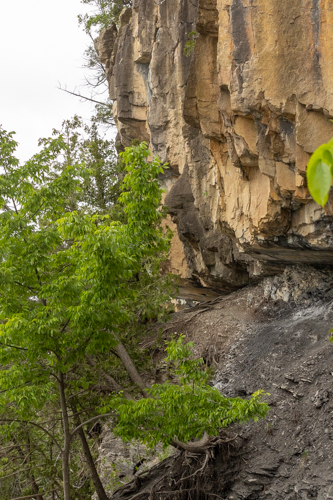
Likewise, dolostone can have profound effects on overlying or bordering communities of plants; as it weathers, it releases the calcium sequestered by ancient seashells and corals into today’s soils. Nowhere in Burlington is this relationship more evident than at Rock Point and Arms Forest, where a superabundance of rare plants (including a beautiful orchid called yellow lady’s slipper) carpet the outcrops of bedrock, and where ranks of white cedar cling to the edges of the cliffs.
Geological maps delineating these sorts of deposits can thus provide crucial clues as to what one might find on site, from rocks to flowers to trees.
But in the Burlington area, bedrock is far from destiny; soils—and surficial geology more broadly—are the ultimate arbiters of bedrock influence, in many cases eclipsing or otherwise mediating access to water and these bedrock nutrients. And this far north, any discussion of surficial geology is really a discussion of glacial history. It’s crucial to note that when the Laurentide ice sheet finally retreated north of the Quebec border about 13,200 years ago, nothing had been spared; not a single mountain had crested the miles thick glaciers; no soils were durable enough to withstand the inexorable flow of ice–in fact, meters of rock had been scoured from the landscape; no animals or plants had survived.
The retreating glaciers, however, loosed meltwaters, and these in turn laid down the rubble that constituted the new soil. This rubble occurred in all different sizes–everything from boulders to sands to micron-sized clay– and as it was swept over the landscape—where it pooled, eddied, or met large bodies of water—rubble accreted and settled out in patterns still recognizable today: the faster the flow, the larger the particle that could be carried; while conversely, only still waters would allow the tiniest clays to settle.
As the glaciers retreated northward, meltwaters pooled in the Champlain Valley, their surface reaching roughly 500 feet overhead. It was during this period that the rich clay and silt deposits accumulated on the ancient lake bottom, today among the highest valued agricultural lands in the state, examples of which are found in the Intervale and the South End. But when the ice dams to the north finally broke, the ancient lake emptied into the Atlantic in matter of hours, roaring out the St Lawrence River valley; but at this time the surrounding land was so compacted by the weight of the glaciers, it was in fact below sea level. And so as this massive lake rushed out, the Atlantic rushed back in. For between 3500 and 4500 years, the Champlain Valley was turned an estuary of the Atlantic known as the Champlain Sea, complete with Beluga whales, harbor seals, dune grasses, and beach pea.
Burlington sits exactly where the ancient Winooski River emptied into this Champlain Sea. The enormous deposits of sand and silt on which the city was built are the remnants of this ancient delta, where the torrent slowed and sediments dropped out. Today, these deposits are seen clearly in sites like Starr Farm, Centennial Woods, and Sunny Hollow in Colchester–here, the soils can be near a hundred feet deep in places, and thus totally independent of bedrock influence. They support vastly different plant communities dominated by pines and blueberries. Communities that are well-suited to the dry, nutrient poor conditions of such well-drained soils. Communities that look nothing at all like those clinging to the bedrock just a few miles away.
Shifting upward
Far from providing an iron-clad set of rules for reading the landscape, these geological considerations interact to seed the endless variation we find in Burlington today. In part two of this article, we will continue our exploration above-ground, connecting these themes and patterns to the rich cultural history here, and to the fascinating variety of plant and animal life.
By Alicia Daniel, Director of Vermont Master Naturalist. This is a reflection on the origin of VMN. It starts with her own journey to become a naturalist.
No one becomes a naturalist by accident. It doesn’t happen because your guidance counselor suggests it’s a good idea. Ask any naturalist. Blazing their own trail will be at the heart of their story.
My “career path” began in the forests, fields, and riversides of Montana, with me watching beavers while my dad and siblings fished for trout or fell into the stream. It took another 20 years to arrive at anything
resembling a trail head. It was a winding path with no map and plenty of dead ends.
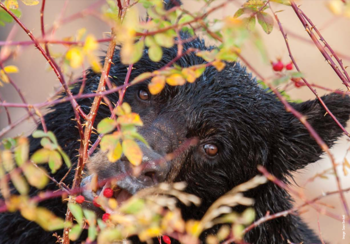
And yet I woke up as a naturalist on an island in Bear Track Cove, Alaska, the summer I turned 28. Yawning from lack of sleep—in the middle of the night, the shush, shush of my eyelashes brush-ing against my sleeping bag sounded like a bear walking around outside my tent—I made my way down to the beach. I’d traveled to Alaska to track black bears. I was, at best, a novice tracker. But when I came upon a set of large pawprints with the mud gooshing up between the five toes, I knew they were fresh and I knew they were bear. I looked across the mudflat that now connected me to the mainland to discover (a) I was not on an island, and (b) the bear tracks led right to a black bear. Backlit by the rising sun, a halo of fur glowed around his head. I stood up, shook off my jacket, and waved it around, as I’d been told to do. He started walking toward me. Black bears in Glacier Bay defend their salmon streams against brown bears, which is to say they are big. Clearly there were safer places to be.
My journey to Alaska actually began a year earlier. After landing my dream job in Austin, Texas, with Bat Conservation International, I’d helped them move from Milwaukee to Austin, overseeing the installation of the phones and watching with pride as workmen bracketed bookshelves to the field station’s freshly sheetrocked walls. I loved the perks of field work, like a trip to Bracken Cave where 20 million Mexican free-tailed bats emerged at sunset like a black tornado. But it was my first day in the new office and I now had an in–person boss and the honeymoon was over. I was sitting at my desk feeling cooped up and claustrophobic, when I heard a metallic rending sound above me that made my hair stand on end. A fully loaded shelf of books torn off the wall, one end hitting a filing cabinet to my right forming a triangular cave with the floor. As I threw myself sideways into this shelter, a thousand pounds of books and shelves crashed down where I had been sitting. I rose up out of the rubble with sudden and sweeping resolve: I was not going to die at a desk slipstreaming behind some famous naturalist. I was going to be a naturalist—or at least die trying.
Every 27 to 29 years, the planet Saturn returns to the sign it was in when you were born. In astrological lore, Saturn is the great taskmaster. He breaks you down, makes you lift heavy weights, so you can get into fighting shape. In my 28th year, I left Bat Conservation International, leapt from an English degree into a Master of Science program, crawled through a flooding cave for my “interview,” moved to Vermont where I figured out how to dress in winter layers (not one big bulky sweater), learned to cross-country ski to the amusement of my peers so I could follow moose through willow thickets in Wyoming, fended of unwanted advances from men who were hired to teach me, and much more. By the time I met up with that black bear, I was in fighting shape. As he stared me down, I slipped quietly into the forest. But later my friend, Michele, and I came back to steal one of his salmon for dinner.
After my encounter with the bear, I got married and spent the next 29 years as a mild-mannered university lecturer raising two children and working part-time as a naturalist. Then, one day when I was walking in the Vermont woods with students, we came upon a black bear skull.
By this time, I had found porcupine skulls, beaver skulls, deer skulls, seal skulls, mouse skulls, raccoon skulls, coyote skulls, fox skulls, and even gull skulls, but never a bear skull. As we turned it over, a long canine tooth fell out of its jaw. I felt a premonition. I took the tooth home and strung it on a leather cord around my neck. Things were about to change. My older daughter was already studying and working in Boston, and my younger daughter was headed off to college, too. My teaching at UVM was drying up
under a new budgeting model. Saturn was returning. I needed to get back into fighting shape.
I dreamed of migrating my naturalist teaching out of UVM (keeping ties only to the Field Naturalist Program) and into Vermont townships. So I started the Vermont Master Naturalist Program. I registered this “school” as a business because I am too old to listen to a board of directors, be routinely audited, write lots of grants, or even complete the necessary nonprofit paperwork. Every step of the process was a bear, from finding insurance to negotiating deals with partners. I quickly discovered that I don’t resonate well with business culture. In my new business–owner role, people either want to sell me things or teach me how to sell things. (Wear red! Be confident! Hand the person you’re talking to your phone so they can’t walk away from you!?!) None of this felt natural or worthwhile to me.
I wanted to find people who dream of being naturalists, create a path for them, help them meet other naturalists, and put them to work on saving nature in their towns. I wanted them to understand that being a naturalist is a practice. It is how you spend your time, not how much you know. People often don’t grow up to be naturalists even when it is their heart’s desire. Now for over 500 people and counting, the Vermont Master Naturalist Program is making that dream come true.
·
On a recent Saturday, I went tracking with Vermont Master Naturalists at a granite quarry where bobcat, coyote, porcupine, and fisher tracks mapped out their travels from the talus to the icy edge of the quarry pool. I am, at best, a middling tracker. But I delight in spending time with people who want to be out in the woods. When I see something magical, I want to turn to a kindred spirit and whisper, “Look”! I have a couple of decades before Saturn returns next time. In the meantime, I will be out in the woods.
This post was originally published here, and here.
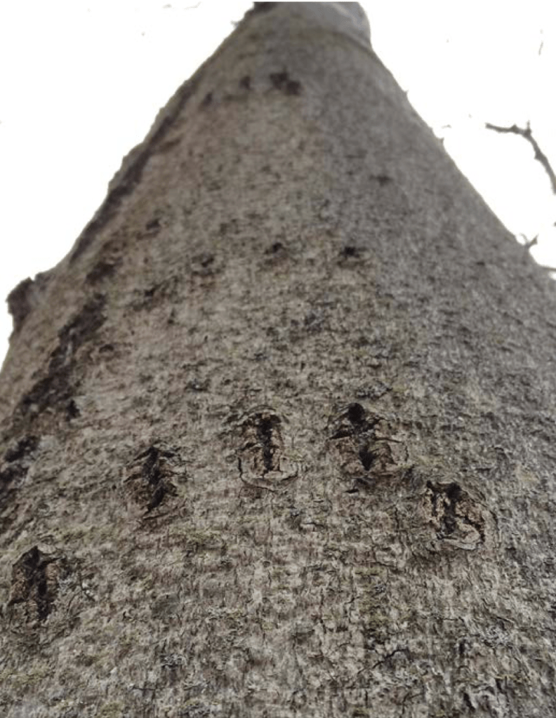
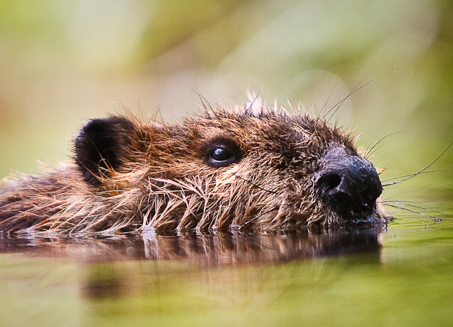
August feels early to be laying in wood for the winter, but we have a wild companion in Burlington who is already building up a cache of winter wood–though the wood is to eat, not to burn. All summer long, beavers cut copious amount of hardwood trees and saplings. They use the limbs to shore up dams and lodges and they cache the inner bark and twigs for food under water near their lodge. Beavers are more elaborate in their winter preparations than any other wild Vermont animal. Unlike migrants, who fly south or resident birds and animals who hibernate or forage on sparse winter fare, a beaver over winters with her clan–cozy in the lodge she has built, living on a pond she helped create, and eating food she has stored.
In Vermont, if a tree falls in the forest, there’s a good chance that a beaver will hear it. Not only are beavers abundant and widespread throughout the state, they are also a primary reason that trees do fall. And not just any trees. Beavers use their chisel teeth to selectively cut hardwoods that grow in close proximity to water. And in the process, they alter landscapes at a scale second only to humans.
Where are the Beavers?
To see evidence of this process at work you can visit Ethan Allen Homestead.
The Homestead is home to a pair of beavers that make their presence unmistakably known. Trees new and old bear scars from beaver chewing, clearly defined beaver paths bridge bodies of water, and the Homestead hosts multiple dams and two beaver lodges. The beavers are active dusk to dawn during the warmer months of the year preparing for the cold winter to come.
Photo Courtesy of: Steven David Johnson
More about Burlington’s Beavers
Beavers accomplish their amazing winter survival by creating the conditions that they need to survive. Beavers use water for cover, for transportation, and for refrigeration. They will emerge above the ice to feed (near an escape hole), to repair a dam, and to seek food in case of emergency, but they are not fast runners on land to begin with and are further hampered by snow. Unfortunately, a beaver on foot in the winter is very vulnerable to predators like coyotes.
Beavers need a body of water deep enough that it will not freeze to the bottom. Using sticks, mud, and even stones, beavers will build dams across flowing rivers and creeks and culverts to create a pond or series of ponds. After a beaver builds a dam and the pond freezes, they may adjust the water level, dropping it by a few inches to create a layer of air under the ice for breathing.
This past winter, the water level was so low after a prolonged drought that the resident beavers in the largest wetland at the Homestead were forced to relocate. They moved from the big wetland (which froze solid) to another lodge in a smaller wetland with deeper water.
According to Vermont naturalist Bernd Heinrich, beavers build “dams that may stretch a hundred or more yards long, and they impound acres of pond where water levels are raised five or more feet.” An all- time record dam was constructed in New Hampshire. It was over three quarters of a mile long and the pond it held up had 40 lodges. Lodges are an adaptation of dam building and are piles of sticks that are later hollowed out and used as homes. People can even fit in abandoned beaver lodges.
Beavers accomplish their engineering feats in groups. They mate for life and a clan may have an adult pair and several yearlings along with kits that are born during the winter in the lodge. The young tag along after the parents, learning the skills they need to survive. There is some evidence that beavers learn their food preferences from their clan.
Beavers are territorial to others outside their clan. They create scent mounds to keep other beavers away and are known to defend their habitat. This past winter a young beaver was found dead at the Ethan Allen Homestead near the lodge of the resident pair. Its cause of death is unclear. Perhaps it was a kit that did not survive the winter or maybe it was an unwelcome beaver looking for habitat in hostile territory.
Beavers are rodents, a group of animals distinguished by their incisors which are covered with enamel in front, but not behind, so that as these animals chew, they wear away the back side, sharpening their teeth like chisels. Beavers turn their heads sideways to bite into standing trees and you can see their teeth marks meeting together on a stump. Beavers close relatives include squirrels, mice, porcupines, and muskrats.
The ponds beavers create are habitat for many plants and animals. The red eft, a small slow moving and bright orange amphibian commonly seen in Charlotte woods in the fall is the immature stage of the Red Spotted Newt. And though the same species is distributed throughout the Southeastern U.S., the terrestrial stage only exists in the Northeast. One hypothesis explaining this pattern is that the Red Spotted Newt is dependent on the beavers to create ponds for breeding habitat in its northern range and the “life span” of a beaver pond is generally only 15 to 20 years. Northern Red Spotted Newts have an eft stage so that they can disperse from the pond to find other habitat, like a new beaver pond.
After a pond is abandoned and drains, a beaver meadow is what remains. As silt accumulates behind a beaver dam, a flat plain is created. When the beavers run out of food or die and the pond is abandoned and drains, this new soil regenerates into a wet meadow–great habitat for animals like moose. Another common pattern that results from beaver activity in a forest is a signature ring of softwoods that persists even after the beavers have moved on. By cutting only hardwoods, beavers create a circle of uncut spruce, pine, fir and hemlocks that surround the higher elevation ponds, while lower elevation ponds have white pine and hemlocks around them. If you look closely you may see the beaver chewed stumps of aspen, birch and maples under this canopy of softwoods.
When explores and colonists arrived in North America, beaver populations were estimated to be between sixty and two hundred million. So, it may come as a surprise that you would have been hard pressed to find even one beaver at the turn of the last century anywhere in Vermont. Hunted to near extinction for their pelts (which were popular in Europe for hats), beavers were only reintroduced into Vermont in 1921.
If you decide to go looking for beavers here are some signs. You have a good chance of seeing one this time of year, especially at dusk. The characteristic sharpened like a pencil look gives beaver sticks an unmistakable appearance.